
 2 months ago
56
2 months ago
56
ARTICLE AD BOX
16 minutes ago
Zoe KleinmanTechnology editor

 Getty Images
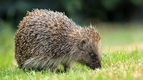
Researchers at the University of Cambridge are using satellite data and AI in an effort to slow the decline in Britain's hedgehog population.
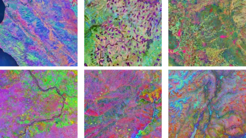
Using an AI tool called Tessera, which analyses detailed images of the UK gathered from space, experts can precisely determine locations of hedgehog habitats - and where these are disappearing.
The resulting maps capture landscapes in minute detail, including down to individual hedgerows, while AI can accurately predict hedgehog-friendly places obscured by cloud cover.
Those behind the project hope it will help to shed light not just on where hedgehogs live across the UK, but barriers preventing them from finding food and mates.
The researchers say Tessera's outputs can be used to track the impact of new housing developments and other environmental changes on landscapes that could affect hedgehogs over time.
Such insights can also be combined with data gathered elsewhere - including tiny GPS trackers physically attached to some hedgehogs to monitor their movements in real time.
But it comes as researchers also look to use AI systems and models that can crunch lots of data and surface patterns within it to aid conservation efforts around the world.
Some, however, have urged caution around using the power-hungry tech, citing fears about its impact on the environment.
Hedgehog populations have declined dramatically across Europe in recent decades.
And in the UK, a 2022 report estimated their numbers to have fallen by up to 75% in rural areas since 2000.
But Prof Silviu Petrovan, strategy and research manager at People's Trust for Endangered Species, says he is optimistic that AI can help protect the tiny mammals.
"What we're really hoping is that we can use these really powerful models to understand, for instance, what are the very specific barriers for hedgehogs to find food and find their mates, and be able to safely move around the countryside?" he says.
He told the BBC researchers behind the project refer to hedgehogs equipped with trackers as "digi-hogs".
To be able to accurately identify the tiny creatures and other objects in image data, the Tessera system had to be trained on vast amounts of data - with around 20 petabytes, or the equivalent of 10 billion standard digital photos, used to build it.
After reaching the limits of the computing power allocated to the university, researchers installed additional processors under their desks to keep the process going.
A new deal with US tech firms AMD and Vultr has also given them access to extra infrastructure.
 University of Cambridge
Tessera's detailed satellite imagery, here capturing six different global locations, has been used to map and classify changes across varied landscapes and terrain
The huge, open-source Tessera system is not just for hedgehogs, however.
Anil Madhavapeddy, professor of planetary computing at Cambridge University, told the BBC that more than 100 research groups have accessed the tool.
The open-source system can also be used to monitor farmland and track which crops are being grown in which fields over time, building a detailed picture of UK agriculture.
"Satellite data is really complicated to use and really noisy, because you have to do things like cloud removal and adjust for day and night, and so on," he said.
"Tessera compresses loads of that data and gives us really easy-to-use maps of the UK, where we can ask really specific questions about things we can see from space."


 English (US) ·